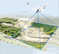
 Uma empresa alemã MAVinci desenvolveu um moderno sistema
de recolha de imagens aéreas num pequeno avião telecomandado com menos de 3 kg
de peso e asa fixa de 1,6 metros. Durante o voo, o UAV segue de forma
autónoma o plano de voo realizado antes da descolagem. A câmara a bordo tira imagens
automaticamente que guarda numa memória. Depois do voo as imagens são
pós-processadas para se obter uma imagem de grande tamanho. Os veículos aéreos
não tripulados MAVinci são capazes de voar de forma automática ao longo de
uma rota planificada por meio de navegação GPS.
SIRIUS I está especialmente desenhado para a documentação e
representação de:
Cartografia
Distritos urbanos
Seguimento de obras
Zonas de desastre
Cultivos e bosques.
Topografia áreas em construção
Topografia de prados e campos
Topografia de áreas de disposição de resíduos
Pedreiras
A área que pode ser coberta durante o voo com SIRIUS I
depende da distância ao solo (GSD Ground Sampling Distance). Num
voo de 40 minutos pode cobrir-se:
No caso da computação de ortofotos:
500 ha a 10 cm de GSD
150 ha a 2 cm GSD
No caso do cálculo do modelo de elevação digital / true
orthofoto
130 ha a 10 cm de GSD
45 ha a 2 cm GSD
_____________* * * * ______________
A German
company, MAVinci developed a modern system of collecting aerial images with a
small remote controlled plane, it is a fixed wing with about 1.6 m wingspan and
less than 3 kg take off weight. During the flight, the UAV follows
independently conducted the flight plan before takeoff. The camera takes
pictures automatically. After the flight images are post-processed to obtain an
image of large size. The unmanned aerial vehicles are able to fly MAVinci
automatically along a planned route using GPS navigation.
SIRIUS I is
mainly used for the following applications:
- cartography
- Urban residential districts
- Construction sites
- Disaster zones
- Crop and forest damages
- Topography of developmental areas
- Topography of meadows and fields
- Topography of waste disposal areas
- Survey of Stone quarries
The area
that can be covered during the flight with SIRIUS I depends on the distance to
the ground (GSD: Ground Sampling Distance). A flight of 40 minutes can cover:
In the case
of computing of orthophotos:
·
500
ha at 10 cm GSD
·
150
ha to 2 cm GSD
In the case
of calculating the digital elevation model / true orthofoto:
·
130 ha at 10 cm GSD
·
45 ha to 2 cm GSD


Sem comentários:
Enviar um comentário